Ridership Optimization Model of Transit-Oriented Development in Jakarta
Published at : 17 Jul 2025
Volume : IJtech
Vol 16, No 4 (2025)
DOI : https://doi.org/10.14716/ijtech.v16i4.6522
Karina, K, Sumabrata, RJ & Berawi, MA 2025, ’ Ridership optimization model of transit-oriented development in Jakarta’, International Journal of Technology, vol. 16, no. 4, pp. 1348-1361
| Karina Karina | Department of Civil Engineering, Faculty of Engineering, Universitas Indonesia, Kampus UI Depok, Depok 16424, Indonesia |
| Jachrizal Sumabrata | Department of Civil Engineering, Faculty of Engineering, Universitas Indonesia, Kampus UI Depok, Depok 16424, Indonesia |
| Mohammed Ali Berawi | Department of Civil Engineering, Faculty of Engineering, Universitas Indonesia, Kampus UI Depok, Depok 16424, Indonesia |

Transit-Oriented Development (TOD) is an urban planning concept focusing on sustainability. One of TOD's functions is to encourage the use of public transportation and increase transit ridership. Several studies have focused on planning TOD to increase the number of transit users, but they only focus on planning at the station area level, which relates to the gross floor area (GFA) of land-use development as the decision variable. This research is intended to fill the gap of previous research by offering an optimization model for land-use allocation based on linear programming and system dynamics at the parcel level of TOD on built-up land based on Mass Rapid Transit (MRT) to maximize MRT transit passengers. The objective of this research is to obtain the optimal GFA for each property development to achieve the maximum level of passenger travel. This study found that the optimal land composition to produce maximum ridership was residential by 27%, commercial by 23%, offices by 11%, government by 12%, hotel by 5%, and other land development by 22%. The potential increase in ridership with this land composition can increase up to 6% from the daily average of the existing MRT Jakarta ridership today.
Land-Use, Optimization Model, Ridership, TOD
Urbanization in Indonesia continues to increase yearly, data from 2010 – 2020 states that the level of urbanization in Indonesia has risen to 56.64% (Statista, 2022). Urbanization occurs for many reasons, such as land use changes, job hunting, access to education and health services, hopes to improve living standards, and massive urban growth (Hidayati, 2021; Widiawaty, 2019). However, rapid and irregular urban growth often presents challenges such as traffic congestion, air and water pollution, loss of green land, and increased social inequality (Murakami et al., 2015). Therefore, a development concept that focuses on sustainability is needed to overcome the negative impacts of urbanization and ensure the quality of the cities for the community.
Transit-Oriented Development (TOD) is a sustainability-focused concept (Saroji et al., 2020). TOD is a mixed-use community centered around transit nodes like trains, Bus Rapid Transit, or rapid transit systems to reduce reliance on private vehicles (Carlton, 2007). TOD has two business interests: transit operators aim to increase passenger numbers, and property businesses aim to raise land values around stations (Transport Research Board, 2004). As the TOD concept evolves and land use adapts to prioritize public transportation, ridership from the region’s main transit systems is expected to reach optimal levels (Huang et al., 2021; Wey et al., 2016).
The Government and PT. MRT Jakarta has recognized the importance of sustainable urban development and are implementing it by developing five MRT stations with TOD concepts: Lebak Bulus, Fatmawati, Blok M (including Blok M and Sisingamangaraja Stations), Istora Senayan (including Istora Mandiri and Senayan Stations), and Dukuh Atas (MRT Jakarta, 2019a). The TOD development aims to reduce private vehicle use by providing public transportation and promoting walking and cycling. Additionally, the MRT was built to alleviate congestion that the TransJakarta lane could not solve due to bus lanes and road overlaps (Ardi et al., 2024). It also aims to improve access to jobs and economic resources and increase land value in nearby areas.
Several studies have explored TOD planning aimed at increasing transit ridership (Khosravi et al., 2024). However, these studies primarily focus on station-area-level planning rather than parcel-level planning, which involves using the Gross Floor Area (GFA) of land-use development as a key decision variable. This study intends to fill the gap of previous research by offering a land-use allocation optimization model based on linear programming and dynamic systems at the parcel level of TOD on MRT-based built-up land to maximize MRT transit passengers. The focus of this research is to obtain the optimal GFA for each property development as an alternative approach to transit operations and property development planning to achieve maximum levels of passenger travel. The study focused on the utilization of space within TOD areas to generate optimal ridership from their development, which is crucial to ensure that TOD development is not in vain and can maximize its own functions. By analyzing and creating a TOD Optimization model, the results can be used as a guideline for future improvements and benchmarks for other TOD masterplans across Indonesia. The potential future improvements include providing clear guidance on how residential rental prices are affected by proximity to transit stations and other geospatial factors and how transportation planning and land use can be better integrated to create more affordable housing and fairer distribution (Yang et al., 2024).
2. Literature Review
2.1. Travel Demand Modeling
In this study, modeling was carried out using trip generation and modal split to obtain the ridership number from the five TOD MRT Jakarta area plans. Trip generation aims to predict the number of trips raised and drawn by each TOD. This stage of the model development process only focuses on the number of trips that begin or end in each area but does not create relationships between zones (Fithra, 2018). The next stage is a modal split that aims to predict travel: the choice of travel mode makers (Vanoutrive and Huyse, 2023). The value of modal split in this study was obtained from the average value of modal split obtained by literature studies and TOD benchmarks in several countries.
2.2. TOD Benchmark
This study builds upon the findings of Berawi et al. (2020), which identify three successful TOD areas using Cervero's 'variable D' framework: density, diversity, design, accessibility, and distance to transit. The first is Union Square in Kowloon, Hong Kong, featuring a mixed-use development with an integrated transit station. The second is Namba Park in Osaka, adjacent to Sekai station and including shopping arcades and other facilities. The third is D-Cube City in Seoul, a complex with direct access to Shindorim Station. Berawi's research details the variables used to analyze these successful TODs as follows Table 1. These TOD variables will be reviewed for each TOD location along the Jakarta MRT Phase 1 corridor and will be compared with the variables from the three benchmark TOD locations.
In calculating ridership in this study, a basic approach of travel demand modeling was utilized, which only encompasses trip generation and modal split. This research employs a two-stage approach, combining qualitative and quantitative methods, to achieve two objectives: (1) developing a basic model for TOD passenger mode and (2) figuring out how TOD mixed land use will optimally increase transit passengers. To achieve the first goal, the basic function and proportion of mixed land use must be determined by analyzing TOD functions, comparing TOD models through literature studies, and collecting TOD Benchmark data from various countries that successfully increase the number of transit ridership. To achieve the second goal, the Optimization model is obtained with a linear programming approach (LP) and dynamic systems, which are then analyzed comparatively both in terms of differences between existing ridership, their relationship with existing capacity, and their relation to operator business and the value of surrounding land.
Table 1 TOD Performance Variables for Benchmark Comparison
The study location is in five Jakarta MRT TOD development plans located along the south-north corridor of MRT Jakarta Phase 1: TOD Lebak Bulus, TOD Fatmawati, TOD Blok M-Sisingamangaraja, TOD Istora-Senayan, and TOD Dukuh Atas as can be seen on Figure 1. The detailed design data for the development of the TOD project comes from the DKI Jakarta Governor's Regulation on City Design Guidelines (PRK) for Transit-Oriented Development Areas from the five TOD areas. The research data is secondary data obtained from PT Integrasi Transit Jakarta, supplemented with data from TOD benchmarks.
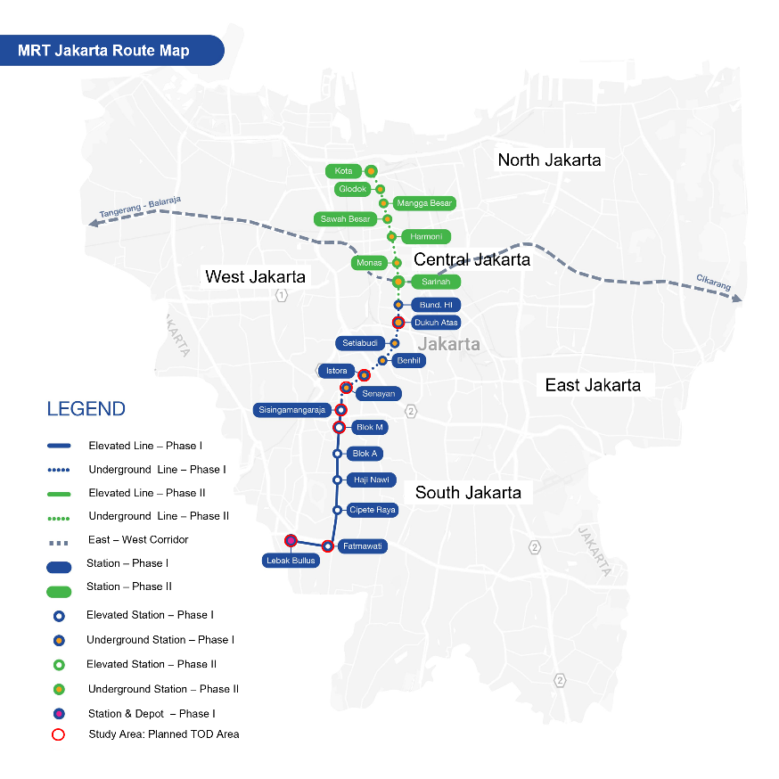
Figure 1 Map of MRT Jakarta Network and Location of Study Area (MRT Jakarta, 2019b) (adjusted: Study Area)
This location was chosen because the five MRT TODs represent the largest TOD plans currently in Indonesia, with all TOD developments in other areas benchmarked against these five TOD zones. Therefore, a detailed study on land optimization in these five TODs is necessary to generate optimal ridership, serving as a foundation for TOD development in other areas.
3.1. Linear Programming
The calculation of daily ridership using the area per capita requirement approach is an effective method for areas with incomplete development details (Hendrigan and Newman, 2017). To create a linear program model, three main components are needed: the goal function, the constraint function, and the decision variable (Hillier and Lieberman, 2021). To formulate a linear programming model, transit ridership is modeled as a goal function where magnitude must be maximized. A combination of each land use's GFA is used as a decision variable to maximize the objective function. The limitation of the decision variable is the land availability in each TOD area. Then, the linear program model in this study can be defined as follows:

Where Z is the amount of ridership resulting from a combination of six decision variables: Residential (X1), Commercial (X2), Office (X3), Government(X4), Hotels (X5), and Others (X6). While 1, 2,3,4, 5, and 6 are the coefficients of the generation rate of transit travel for each land-use. The constraint function is defined as each land use (equation 2 & equation 3). The constraint function is defined as each land use's maximum and minimum GFA percentage.

3.3. Dynamic System Model
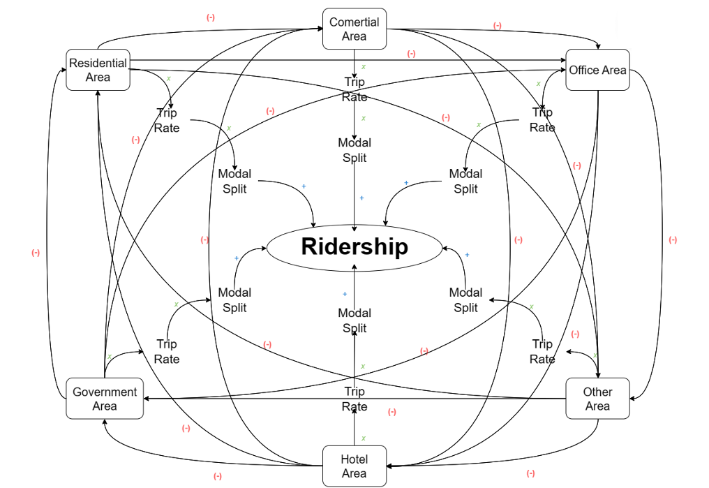
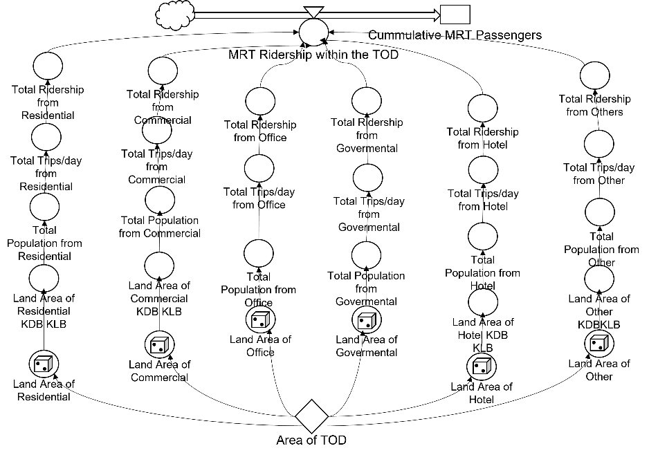
The main principle of system dynamics is to provide a detailed understanding of how each element interacts, provide optimal system performance results, and predict future system performance. Several things affect the relationship of the system: Causal Relationship, Stock and flow, Delay, and Nonlinear. Dynamic system modeling in this study is only affected by Causal Relationships and Stock and flow.
A causal loop of each variable and stock flow diagram is used to determine the optimization model precisely using the dynamic system. From the figure below, we know the causal relationship between each variable (Figure 2(a)). After defining the causal loop, the relationships between all the variables can be drawn on the stock-flow diagram to create the dynamic optimization model of ridership for each land use (Figure 2(b)).
The ridership value is obtained from the sum of the land area of each land use multiplied by the trip rate and modal split of each land use. The travel behavior of individuals in the Jabodetabek area involves making trips between one and three times per day (JICA, 2019). Therefore, the trip rate is utilized to represent this value. The relationship of each land-use is mutually reducing because there are boundaries in the form of existing land TOD areas, so the GFA percentage of each use will change dynamically depending on the increase and decrease in GFA of each land-use combination. The stock-flow diagram is created to represent the relationships shown in the causal loop. In developing the dynamic system model for this study, the PowerSim application was used to obtain a ridership optimization model for the five TOD MRT Jakarta study areas.
One example of using this method is conducted by Ewing, who utilized system dynamics to determine that in TOD areas, pedestrian rates are at 45.8%, and railway users are at 16%. These figures are significantly higher compared to Transit-Adjacent Development (TAD) concepts, which only reach 3.6% for pedestrians and 4.1% for railway users at Orenco Station (Ewing et al., 2019). This method is also employed for Airport Characterization in Hub-and-Spoke Networks in Yuliawati's study (Yuliawati et al., 2015).
(a)
(b)
Figure 2 (a) Causal Loop (left) and (b) Stock Flow in This Study (right)
3.3. Benchmark TOD Model
Benchmark results from successful TOD in three countries became the main guidelines for this study. Each of the 'variable d' of TOD Union Square, Namba Parks, and D'Cube City will be analyzed. Regarding design variables and destination & and transit accessibility, Union Square has the most efficient integration design where residential, office, and other buildings sit atop the commercial podium housing the Kowloon station. In addition, a multifunctional area located at a distance of about 200 m from the transit station encourages residents to walk because easy and convenient access is available.
The "Diversity" variable indicates that five types of land use must be present to achieve the desired diversity level in a TOD area: Residential, Commercial, Urban, Hotel, and Other land development. "Other" refers to land uses such as Green Space, Blue Space, Road Access, etc. The "Density" variable is calculated as the Floor Area Ratio (FAR), which is the ratio of total floor area (GFA) to land area. The results obtained FAR values from all three regions' Benchmarks in the range of 6.79 – 8.07 with an average FAR of 7.43. The composition of the type of land development, GFA, total land area, and FAR of each TOD Benchmark is summarized in Table 2.
Table 2 Land Composition on TOD Benchmark.
3.4. Existing MRT Jakarta TOD Development: Case Study
The five TOD plans in Jakarta are in the areas that have been built and have their respective functions and zoning, as reported in the DKI Jakarta Governor's Regulation regarding RDTR in 2022. The zoning division is contained in the Jakarta MRT TOD Area City Design Guide (PRK), where the composition of existing land in the Jakarta MRT TOD area plan can be seen in Table 3, while the plan for additional land development is in Table 4. The composition of existing land in each TOD area is diverse. Land development is classified into 6 categories: Residential, Commercial, Office, Government, and Others, consisting of green space, blue space, road access, terminals, educational facilities, worship facilities, and health facilities. Meanwhile, the plan to add land, according to PRK, is not diverse enough, which only includes adding land for affordable housing (residential) and affordable business space (commercial) and additional developments such as adding green space, open plazas, and accessibility support facilities. Even in TOD Istora-Senayan, there is no additional function of residential and commercial land because, based on the results of multi-criteria analysis, the study of affordable housing development in TOD Istora-Senayan does not allow for the development of affordable flats. The main factors are the area's land value, which is already very high, the availability of land, and the absence of assets owned by the DKI Jakarta Provincial Government in the area.
Table 3 Composition of Existing Land in MRT Jakarta Area Plan (m2)
Because the planned area is not vacant land, all types of land development need to be considered to determine the amount of ridership generated from each TOD area. A summary of the design development of the five TOD MRT Jakarta in terms of land-use allocation and the proportion of floor area is presented in Table 5. From PRK, five TOD areas were obtained, including Lebak Bulus, Fatmawati, Blok M-Sisingamangaraja, Istora-Senayan, and Dukuh Atas; it can be seen that the orientation of TOD area development is only focused on residential and commercial properties that take a large portion of TOD land-use, while the development of office areas is not carried out because there are already around 21% of the total GFA from the existing area. It can also be seen that there is no type of hotel development in the entire TOD area.
Table 4 Additional Land Development Based on PRK (m2)
Table 5 Land Composition and Number of Ridership in MRT Jakarta TOD Plan
Ridership calculations are obtained using the value of the required space per person and the value of the modal split. The value of the minimum required space from each land use refers to some standards such as SNI 03-1733-2004, and other (Berawi, et al., 2020; Maryanti et al., 2016; Hung et al., 2009; National Standardization Agency, 2004). The modal split value is refers to some journal for each land use (Berawi et al., 2021; Wang et al., 2019; Wen and Yu, 2019; Nelson and Sanchez, 2018; Yin & Liu, 2018; Aoki et al., 2017; Clifton et al., 2015; Vincent et al., 2012). Both required space per person, and the modal split was then elaborated on with each other.
The smallest value of the minimum required space per person is used because TOD is a high-density development, so the allocation of space per person must be minimal but within the standards set in the building planning criteria. In contrast, for 'other' types of development, which encompass various land development types, an average of the required space per person for each type is employed. The value for the modal split is derived from the average found in various literature studies, demonstrating that TOD effectively enhances train ridership across all types of development.
Thus, to calculate the magnitude of the ridership value, a parameter of the generation rate of transit travel is needed (see Eq. (1)), where the value is obtained by multiplying the modal split value of rail transport and the area of space required per person in the building plan (Table 6). (Badan Standarisasi Nasional, 2004)
Table 6 Parameter for Determining the Objective Function of Ridership
Berawi, in his research, did not calculate 'other' land functions because it was assumed that the type of development was in the form of green space and did not produce a large travel generation. However, in this study, other types of land development are a combination of various types of development that can provide travel generation, the value of area needs per person, and modal split from this development function is the average of several values owned by the land functions of green space, blue space, road access, terminals, educational facilities, worship facilities, and health facilities. With this land composition, the average daily ridership of the five TOD areas is 266,908 trips/day.
4.1. Ridership TOD Model: Linear Programming
The linear programming optimization model is based on the diversity parameter of the TOD benchmark as a function of constraints, where the GFA composition range of each type of development is used, and the parameters in Table 8 are used as trip generation rate to obtain the destination function (see Eq. (1)). Because the study area is an area that is already built up, there is an additional boundary function; the total GFA of all types of development must be less than the total GFA of the TOD area. Another limiting function is that the GFA of each type of development must be in the range according to the composition of the land in the TOD benchmark (Table 2). In addition to fulfilling the diversity parameter, a TOD area must include six types of development. Therefore, based on the explanation above, the ridership optimization model with the linear programming method can be defined as follows:

The above model is used to optimize the composition of land development types to maximize the MRT's daily ridership in the Jakarta MRT's five TOD areas. Where eq. (4) is the basic function for computing land optimization, and equation 5 – equation 12 represents the constraint functions of the basic function. So based on the linear programming optimization model, the composition of land that produces maximum ridership is obtained, namely: residential 28%; commercial 18%; office 12%; government 14%; hotels 4% and others 24%, where the average daily ridership generated from each TOD area is 275,686 trips/day or an increase of about 5% from ridership with land composition by the PRK plan. The summary of the percentage of land composition and ridership of each TOD area can be seen in Table 7.
Table 7 Land Composition and Number of Ridership in The Linear Programming Optimization Model
4.2. Ridership TOD Model: Dynamic System Modeling
In the dynamic system optimization model, the  quantity is not used to determine the trip generation rate of each type of land development (Equation. 1). To replace it, the average trip per day generated from each type of development is used. The value is derived from a survey of travel behavior conducted both through paper-based and mobile-based methods involving residents of the Jabodetabek region (JICA, 2019; Wismadi et al., 2013).
The calculation of ridership with a dynamic system model is depicted as a stock-flow diagram in the PowerSim application based on causal loops such as Figure 3. The GFA composition range of each type of land development from the TOD benchmark is also used as a limitation in this method. The dynamic system determines various alternative land compositions that can occur with existing borders. The ultimate goal is to get the most optimal composition of land development types to get the maximum ridership size. So based on the dynamic system optimization model, the most optimal land composition is obtained to produce maximum ridership, namely: residential 27%; commercial 28%; office 10%; government 10%; hotels 5% and others 19%, where the average daily ridership generated from each TOD area is 287,557 trips/day or an increase of about 11% from ridership with land composition by the PRK plan. The summary of the percentage of land composition and ridership of each TOD area can be seen in Table 8.
A Comparison of the land composition of the future TOD with the Optimization model can be seen in Figure 3, where the most optimal land composition model in the Jakarta MRT TOD to generate maximum ridership is with a residential land composition of 27%, commercial 23%, offices 11%, government 12%, hotels 5% and other types of land development by 22%. With this land composition, the daily MRT ridership can increase up to 5% in Lebak Bulus TOD, 25% in Fatmawati TOD, 2% in Blok M-Sisingamangaraja TOD, 4% in Istora-Senayan TOD, and 3% in Dukuh Atas TOD.
Table 8 Land Composition and Number of Ridership in Dynamic System Optimization Model
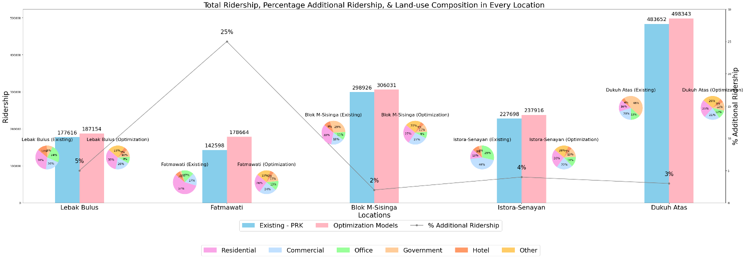
Figure 3 Total Ridership, Percentage Additional Ridership, & Land-Use Composition in Every Location
4.3. Comparison with MRT Jakarta Capacity
Another question that needs to be discussed after the creation of this model is whether the Jakarta MRT transit operator can accommodate all potential ridership daily resulting from the development of the five TOD areas along its corridor. It is known that currently, PT MRT Jakarta (Perseroda) applies an operating schedule at 05.00-24.00 WIB every day, valid Monday-Friday with an interval of train departures every 5 minutes during 7.00-9.00 WIB and 17.00-19.00 WIB, otherwise every 10 minutes. While on weekends, MRT Jakarta operates from 05.00-24.00 WIB with an interval of departure time every 10 minutes. The capacity of a series of Jakarta MRT trains is 1950 people. It is recorded that the number of MRT Jakarta ridership from January 1st, 2023, to April 25th, 2023, reached around 9.4 million people with an average number ridership daily of 81,000 people/day.
The average daily ridership will increase to 281,622 people/day. This means the daily ridership will increase by three times from the current condition. TOD characteristics have a significant positive impact on MRT stations. Stations located in areas with stronger TOD characteristics tend to have higher ridership compared to those in areas with weaker TOD characteristics (Khosravi et al., 2024). With a capacity of 1950 people in a series that operates for 6 hours during peak hours and 13 hours during normal hours in a day, it is known that the capacity of the MRT in a day is 292,500 people. It should be noted that 281,622 people/day is the average daily ridership. However, when viewed in detail in Table 9 and Table 12, the daily ridership capacity of some TOD areas exceeds the current capacity of the MRT Jakarta.
The daily ridership from the Dukuh Atas TOD area is 504,970 people/day (Table 8), so to be able to accommodate all passengers, the required frequency from the MRT is every 4 minutes for 19 hours of operational time. The potential for improvement ridership is likely to increase even higher, considering that the average FAR of these five TOD regions is only 2,608 (Table 5). While the TOD parameter as a high-density area must have a FAR value of 5 – 11 (Governor of DKI Jakarta Province, 2022; Iskandar et al., 2021). Therefore, PT. MRT Jakarta needs to accommodate the anticipated increase in ridership by significantly expanding the GFA of developments in all five regions. PT. MRT Jakarta should also prioritize improving the frequency and coverage of transit services to ensure equitable mobility options for residents in these areas (Zhao et al., 2024).
4.4. TOD Ownership System and Its Impact on Operator Business & Land Value
According to Cervero & Guerra, one of the main functions of TOD is to increase train ridership and operator revenue (Guerra and Cervero, 2010). In many cases, TOD development has been shown to increase rail usage and generate additional revenue for transit operators (Berawi et al., 2019). Cervero & Landis’s research shows that TOD in U.S. metropolitan areas, such as Portland and Denver, has significantly increased rail ridership and carrier revenues (Cervero and Landis, 1995). Transportation operators, such as East Japan Railway Company (JR East) and West Japan Railway Company (JR West), play a crucial role in providing transportation infrastructure that supports TOD. They frequently collaborate with developers to ensure that stations and transportation routes are well-integrated into urban development plans (Utsunomiya et al., 2023).
In Indonesia, TOD ownership is not always owned by transit operators. For example, in the Istora-Senayan TOD area, no land is owned by the DKI Jakarta government. In contrast, TOD development in Indonesia often involves private parties, property developers, or other business entities with land ownership around transit stations. The lack of synergy between traffic operators and TOD owners in Indonesia can be a burden in optimizing TOD's potential to increase ridership. In Taiwan, transportation operators such as the Taiwan High-Speed Rail Corporation and local rail companies invest in the development and enhancement of transportation infrastructure. They collaborate with the government to ensure effective integration between stations and surrounding land use. For successful TOD, synergy among the government, transportation operators, private developers, and the community is crucial. The government handles regulation and planning, transportation operators provide infrastructure, private developers build properties, and the community offers feedback and benefits from the development (Yen et al., 2023).
The lack of synergy between stakeholders can hinder increased ridership due to the lack of alignment in the development of the area around the station with transit operators' needs and operational strategies. Effective implementation of TOD can provide significant benefits in increasing the value of land around transit stations. By turning the land around the station into an integrated hub of activities with the public transport system, the value of the land will increase substantially.
This study aims to create a model of land-use allocation optimization based on linear programming and dynamic systems at the parcel level of TOD on MRT-based built-up land to maximize MRT transit passengers. The main focus of this research is to obtain the optimal GFA for each property development as an alternative approach to transit operations and property development planning to achieve maximum levels of passenger travel. Based on the results of the study, it is known that the optimal land composition to produce maximum ridership is residential by 27%, commercial by 23%, offices by 11%, government by 12%, hotels by 5%, and other types of land development by 22%. The potential result of increasing ridership with the composition of the land can increase up to 6% from the current average daily ridership of MRT Jakarta. A key takeaway from the study is its potential to offer valuable insights for urban planning, especially in integrating land-use allocation with transportation systems in TOD areas. The results also offer a framework that can guide property developers in optimizing land-use compositions to maximize both transit ridership and property values. For instance, prioritizing residential and commercial developments, which have been shown to contribute significantly to ridership, could become a central strategy. Moreover, achieving the optimal land composition in this study highlights the need for government intervention, particularly in consolidating land in areas with fragmented ownership. In addition, there is room for further exploration to build upon the findings and address potential gaps in the research. Future studies could investigate broader socio-economic impacts of TOD implementation or evaluate the model's adaptability to varying urban conditions. For instance, Jakarta’s ongoing transit projects, along with emerging transit developments in cities like Surabaya, Bandung, and Medan, could serve as meaningful case studies to refine and extend the applicability of this approach.
The authors would like to express their sincere gratitude to the Transportation Laboratory, Department of Civil and Environmental Engineering, Faculty of Engineering, Universitas Indonesia (FTUI), for serving as the research center and providing continuous support throughout the course of this study.
Aoki, Y, Ota, J & Nagase, T 2017, 'Transit-oriented development and household travel behavior: A case study of Tokyo', Journal of Transport Geography, vol. 60, pp. 130–137
Ardi, R, Widjaya, T, Putri, SA & Syaifullah, DH 2024, 'Multi-generational analysis on behavioral intention to use public transportation using structural equation modeling: Evidence from Indonesia', International Journal of Technology, vol. 15, no. 2, pp. 310–320, https://doi.org/10.14716/ijtech.v15i2.6704
Berawi, MA, Calista, M & Gunawan 2021, 'Mode split analysis for transportation in residential and office of transit-oriented development (TOD)', IOP Conference Series: Earth and Environmental Science, vol. 794, no. 1, https://doi.org/10.1088/1755-1315/794/1/012051
Berawi, MA, Saroji, G, Iskandar, FA, Ibrahim, BE, Miraj, P & Sari, M 2020, 'Optimizing land use allocation of transit-oriented development (TOD) to generate maximum ridership', Sustainability (Switzerland), vol. 12, no. 9, pp. 1–20, https://doi.org/10.3390/su12093798
Berawi, MA, Suwartha, N, Elrizqi, M, Saroji, G & Sari, M 2020, 'Developing mobile application for residential property business in transit-oriented development areas', International Journal of Technology, vol. 11, no. 7, pp. 1348–1358, https://doi.org/10.14716/ijtech.v11i7.4481
Berawi, MA, Wicaksono, PL, Gunawan, Miraj, P & Rahman, HA 2019, 'Life cycle cost analysis of the transit-oriented development concept in Indonesia', International Journal of Technology, vol. 10, no. 6, pp. 1184–1193, https://doi.org/10.14716/ijtech.v10i6.3621
Berawi, Mohd Ali, Ibrahim, BE, Gunawan & Miraj, P 2019, 'Developing a conceptual design of transit-oriented development to improve urban land use planning', Journal of Design and Built Environment, vol. 19, no. 1, pp. 40–48, https://doi.org/10.22452/jdbe.vol19no1.4
Carlton, I 2007, 'Histories of transit-oriented development: Perspectives on the development of the TOD concept (Working paper 2009-02)', Institute of Urban and Regional Development University of California, Berkeley, pp. 1–30
Cervero, R & Landis, J 1995, 'Twenty years of the bay area rapid transit system: Land use and development impacts', Transportation Research Part A: Policy and Practice, vol. 30, no. 4, pp. 309–333
Clifton, KJ, Currans, KM & Muhs, CD 2015, 'Adjusting ITE’s trip generation handbook for urban context', Journal of Transport and Land Use, vol. 8, no. 1, pp. 5–29, https://doi.org/10.5198/jtlu.2015.378
Ewing, R, Tian, G, Park, K, Sabouri, S, Stinger, P & Proffitt, D 2019, 'Comparative case studies: trip and parking generation at Orenco Station TOD, Portland Region and Station Park TAD, Salt Lake City Region', Cities, vol. 87, pp. 48–59, https://doi.org/https://doi.org/10.1016/j.cities.2018.12.020
Fithra, H 2018, Model transportasi barang, Unimal Press, http://repository.unimal.ac.id/id/eprint/4183
Governor of DKI Jakarta Province 2022, Governor Regulation of DKI Jakarta on Detailed Spatial Planning of the Planning Area of DKI Jakarta Province, pp. 1–200
Guerra, E & Cervero, R 2010, 'Transit-oriented development in Latin America: A comparative study of Santiago and Curitiba', Journal of Transport Geography, vol. 18, no. 5, pp. 665–675
Hendrigan, C & Newman, P 2017, 'Dense, mixed-use, walkable urban precinct to support sustainable transport or vice versa? A model for consideration from Perth, Western Australia', International Journal of Sustainable Transportation, vol. 11, no. 1, pp. 11–19, https://doi.org/10.1080/15568318.2015.1106225
Hidayati, I 2021, 'Urbanisasi dan dampak sosial di kota besar: Sebuah tinjauan', Jurnal Ilmiah Ilmu Sosial, vol. 7, no. 2, article 212, https://doi.org/10.23887/jiis.v7i2.40517
Hillier, F & Lieberman, G 2021, Introduction to Open Research (11th Editi), McGraw-Hill
Huang, X, Liang, Q, Feng, Z & Chai, S 2021, 'A TOD planning model integrating transport and land use in urban rail transit station areas', IEEE Access, vol. 9, pp. 1103–1115, https://doi.org/10.1109/ACCESS.2020.3047207
Hung, J, Monsees, J, Munfah, N & Wisniewski, J 2009, 'Technical manual for design and construction of road tunnels — civil elements', National Highway Institute, December, p. 702
Iskandar, D, Sumabrata, RJ & Abiyoga, R 2021, 'The development of readiness indicators for transit-oriented areas. Civil Engineering and Architecture, vol. 9, no. 2, pp. 453–461, https://doi.org/10.13189/cea.2021.090218
JICA 2019, JABODETABEK Urban Transportation Policy Integration Project Phase 2 in the Republic of Indonesia, October
Khosravi, H, Abrishami, M, Mehrian, MR & Chamberlain, B 2024, 'The positive impact of transit-oriented-development characteristics on Metro Station usage: A case study of Tehran’s metro stations and TOD index calculation', Cities, vol. 148 (February), p. 104840, https://doi.org/10.1016/j.cities.2024.104840
Maryanti, MR, Khadijah, H, Uzair, AM & Ghazali, MARMM 2016, 'The urban green space provision using the standards approach: issues and challenges of its implementation in Malaysia', Sustainable Development and Planning VIII, vol. 1, pp. 369–379, https://doi.org/10.2495/sdp160311
MRT Jakarta 2019a, Kawasan Berorientasi Transit (TOD), https://jakartamrt.co.id/id/kawasan-berorientasi-transit-tod
MRT Jakarta 2019b, 'Together we create more value', Annual Report, https://jakartamrt.co.id/sites/default/files/2020-09/Annual-Report-MRT-Jakarta-2019.pdf
Murakami, J, Suzuki, H, Hong, Y-H & Tamayose, B 2015, Financing Transit-Oriented Development with Land Values?: Adapting Land Value Capture in Developing Countries
National Standardization Agency 2004, 'SNI 03-1733-2004 Guidelines for Urban Residential Environment Planning', National Standardization Agency of Indonesia, pp. 1-58
Nelson, D & Sanchez, TW 2018, 'Transit-oriented development, parking requirements, and travel demand management: A case study of the metropolitan branch trail in Washington, DC, Transport Policy, vol. 69, pp. 14–21
Saroji, G, Berawi, MA, Sumabrata, J, Ibrahim, BE & Miraj, P 2020, 'Creating added value for urban transit in developing country: A case study of transit-oriented development project', Engineering Journal, vol. 24, no. 4, pp. 33–47, https://doi.org/10.4186/ej.2020.24.4.33
Statista 2022, Indonesia: Urbanization from 2010 to 2020, https://www.statista.com/statistics/455835/urbanization-in-indonesia/
Transport Research Board 2004, 'Transit Cooperative Research Program Report 102: Transit-Oriented Development in the United States: Experiences, Challenges, and Prospects (102nd ed.)', National Academies Sciences Engineering Medicine, https://doi.org/10.17226/23360
Utsunomiya, K, Sanko, N & Keumi, C 2023, 'Expectations and satisfaction towards railway companies by residents in Japan', Research in Transportation Economics, vol. 100 (May), https://doi.org/10.1016/j.retrec.2023.101303
Vanoutrive, T & Huyse, H 2023, 'Revisiting modal split as an urban sustainability indicator using citizen science', Cities, vol. 143 (April), p. 104592, https://doi.org/10.1016/j.cities.2023.104592
Vincent, JM, Bierbaum, AH & McKoy, DL 2012, 'Families and transit-oriented development: Creating complete communities for all', Transit-Oriented Development Best Practice Guidebooks, vol. 1, no. 205
Wang, J, Li, X, Cao, Y & Zhang, Y 2019, 'Impact of built environment and socio-demographics on travel behavior in tansit-oriented development areas: A case study of Beijing', Habitat International, vol. 87
Wen, H & Yu, S 2019, 'Transit-oriented development and modal split: A case study of Hong Kong', Transportation Research Part D: Transport and Environment
Wey, W-M, Zhang, H & Chang, Y-J 2016, 'Alternative transit-oriented development evaluation in sustainable built environment planning', Habitat International, vol. 55, pp. 109–123, https://doi.org/https://doi.org/10.1016/j.habitatint.2016.03.003
Widiawaty, MA 2019, 'Faktor-faktor urbanisasi di Indonesia', Pendidikan Geografi UPI, vol. 2 (April 2019), pp. 1–10, https://doi.org/10.31227/osf.io/vzpsw
Wismadi, A, Soemardjito, J & Sutomo, H 2013, 'Transport situation in Jakarta', Study on Energy Efficiency Improvement in the Transport Sector through Transport Improvement and Smart Community Development in the Urban Area, ERIA Resea (Project Report 2012-29), pp. 29–58, http:/www.eria.org/RPR_FY2012_No.29_Chapter_4.pdf
Yang, S, Peng, C, Hu, S & Zhang, P 2024, 'Geospatial modelling of housing rents from TOD using MGWR and implications on integrated transportation-land use planning', Applied Geography, vol. 170 (June), p. 103356, https://doi.org/10.1016/j.apgeog.2024.103356
Yen, BTH, Feng, CM & Lee, TC 2023, 'Transit-oriented development strategy in Taiwan: An application of land value capture', Asian Transport Studies, vol. 9 (December 2020), https://doi.org/10.1016/j.eastsj.2022.100094
Yin, X & Liu, X 2018, 'Transit-oriented development and modal shift in China: A case study of Guangzhou', Journal of Transport Geography, vol. 66, pp. 96–106, https://doi.org/https://doi.org/10.1016/j.jtrangeo.2017.12.007
Yuliawati, E, Hadiwardoyo, S, Susantono, B & Tjahjono, T 2015, 'System dynamics model for airport characterization in hub-and-spoke networks', International Journal of Technology, vol. 6, no. 5, pp. 733–742, https://doi.org/10.14716/ijtech.v6i5.1039
Zhao, Y, Hu, S & Zhang, M 2024, 'Evaluating equitable Transit-Oriented Development (TOD) via the Node-Place-People model', Transportation Research Part A: Policy and Practice, vol. 185 (June), pp. 1–15, https://doi.org/10.1016/j.tra.2024.104116